

Ghana and Cote d’Ivoire have completed the first phase of a major project to make their international land boundary clearer and easier to identify, commissioning 37 newly constructed boundary pillars along approximately 150 kilometers of the shared border.
The new pillars do not create a new border and do not transfer territory between the two countries. Instead, they physically reaffirm sections of the existing international boundary, replacing or supplementing older markers that have been damaged, displaced, overgrown or become difficult to identify.
The project is being carried out jointly by the Ghana Boundary Commission and Cote d’Ivoire’s National Boundary Commission. The first phase was completed in September 2026, with ceremonies held at New Town in Ghana’s Western Region and Diby in Cote d’Ivoire.
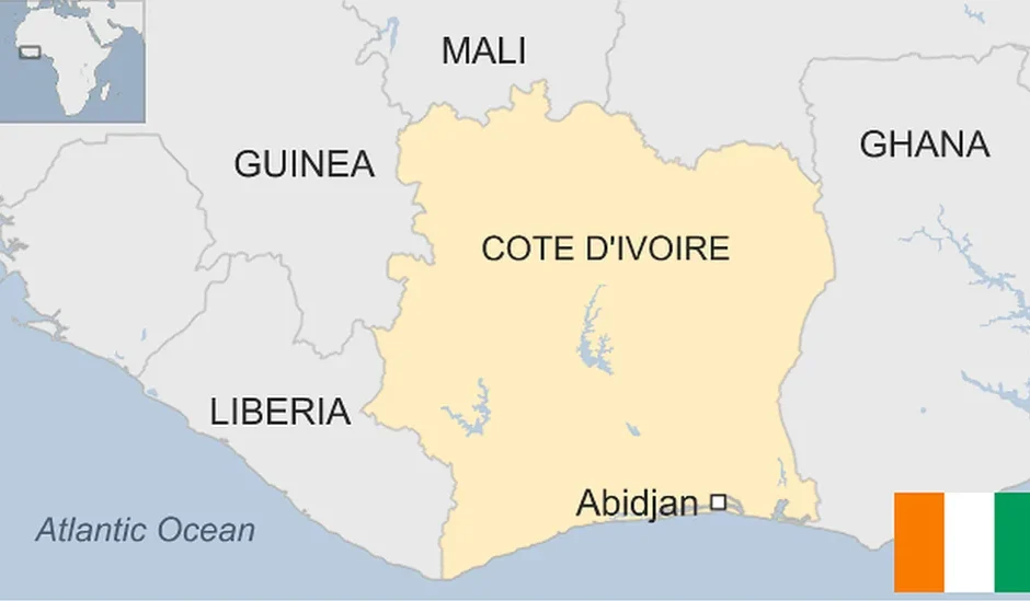
Here is what the new pillars mean, where the Ghana-Cote d’Ivoire border runs, why the boundary is being reaffirmed, and how the current project differs from the countries’ earlier maritime boundary dispute.
Table of Contents
- What Are the 37 New Boundary Pillars?
- Where Were the New Pillars Installed?
- What Types of Boundary Pillars Were Built?
- Do the New Pillars Change Ghana’s Territory?
- Why Was the Border Reaffirmation Necessary?
- Is Ghana in a Border Dispute With Cote d’Ivoire?
- What Happened With the Maritime Boundary Dispute?
- What About Border Crossing Points?
- How Does This Affect Border Communities?
- What Happens in Phase Two?
What Are the 37 New Ghana-Cote d’Ivoire Boundary Pillars?
The 37 structures are official international boundary markers installed as part of Phase One of the Joint Ghana-Cote d’Ivoire Land Boundary Reaffirmation Exercise.
The Ghana Boundary Commission says the first phase covered approximately 150 kilometers of the international boundary.
The pillars provide physical reference points showing where the internationally recognized land boundary runs.
The project was funded by the German development agency GIZ and the African Union Border Programme. Construction was carried out by the 48 Engineer Regiment of the Ghana Armed Forces.
The first phase was formally completed with ceremonies held in September 2026.
Where Were the New Boundary Pillars Installed?
The first commissioning ceremony took place at New Town in the Jomoro Municipality of Ghana’s Western Region.
That ceremony focused on the Terminus Pillar, which marks the point where the Ghana-Cote d’Ivoire international land boundary ends and the maritime boundary begins.
A second ceremony was held at Diby in Cote d’Ivoire, near Yaakase in Ghana’s Western North Region.
That location includes International Boundary Pillar 48, which serves as both a main boundary marker and a border-crossing pillar.
The reaffirmation work therefore stretches through communities and terrain where residents, traders and security agencies routinely interact across the international boundary.
What Types of Boundary Pillars Were Built?
The 37 pillars are not all identical. They perform different functions along the boundary.
| Pillar Type | Number | Purpose |
|---|---|---|
| Terminus Pillar | 1 | Marks the end of the land boundary and the beginning of the maritime boundary. |
| Main Pillars | 12 | Major official reference points along the international boundary. |
| Intermediate Pillars | 20 | Additional markers placed between major reference points to make the boundary clearer. |
| Border Crossing Pillars | 4 | Markers associated with recognized crossing locations along the boundary. |
These pillars help surveyors, security agencies, local governments and residents identify the agreed international boundary on the ground.
Do the New Boundary Pillars Change Ghana’s Territory?
No evidence reviewed for this article indicates that the reaffirmation exercise changes Ghana’s territorial boundaries or transfers land between Ghana and Cote d’Ivoire.
The exercise is described by both countries as a reaffirmation of the existing international boundary.
That means the goal is to identify, restore and physically mark an already recognized border more clearly.
This is different from negotiating an entirely new boundary.
Why Was the Ghana-Cote d’Ivoire Border Reaffirmation Necessary?
Many African international boundaries were originally marked decades ago, and physical markers can deteriorate over time.
The Ghana Boundary Commission has said that some older colonial-era boundary markers have been damaged, destroyed, displaced or covered by vegetation.
Human activity has also affected some markers.
In earlier inspections along Ghana’s western international boundary, the Commission said certain markers had become difficult to identify because of conditions including:
- Dense vegetation.
- Weather and erosion.
- Human activity.
- Illegal mining.
- Damage to older markers.
- Poor access roads.
If an international boundary becomes difficult to identify on the ground, problems can arise over farming, security patrols, local government administration, infrastructure, trade and law enforcement.
Installing visible and jointly accepted markers helps reduce that uncertainty.
Is Ghana Currently in a Border Dispute With Cote d’Ivoire?
The current land-boundary project should not be described as evidence of a new territorial dispute between Ghana and Cote d’Ivoire.
The two governments are conducting the reaffirmation exercise jointly through their national boundary commissions.
Officials from both countries have described clearer boundaries as a way to prevent future disagreements and strengthen cross-border cooperation.
The Ghana Boundary Commission says its land-boundary responsibilities include determining, demarcating and reaffirming Ghana’s international boundaries while promoting cooperation with neighboring states.
Cote d’Ivoire’s boundary authorities have similarly participated in the technical work, construction and commissioning ceremonies.
The current process is therefore cooperative rather than adversarial.
Did Ghana and Cote d’Ivoire Have a Maritime Boundary Dispute?
Yes. Ghana and Cote d’Ivoire previously had a significant dispute over their maritime boundary in the Atlantic Ocean.
That case was brought before a Special Chamber of the International Tribunal for the Law of the Sea, commonly known as ITLOS.
The dispute was particularly important because the offshore area contains oil and gas resources.
In 2017, the Special Chamber issued its judgment establishing the maritime boundary between the two countries.
Since then, Ghana and Cote d’Ivoire have worked through joint technical committees to implement the ITLOS decision and manage their shared boundary.
The current land-boundary reaffirmation exercise is related to that broader bilateral boundary-management process but is not a reopening of the 2017 maritime case.
The new Terminus Pillar is especially important because it identifies the point where the international land boundary ends and the maritime boundary begins.
What About Ghana-Cote d’Ivoire Border Crossings?
The international boundary is more than a line on a map. It passes through areas where people cross for trade, family connections, transportation and other daily activities.
The new first-phase project includes four Border Crossing Pillars designed to make recognized crossing areas clearer.
One of the best-known official crossings between Ghana and Cote d’Ivoire is at Elubo in Ghana’s Western Region, opposite Noe in Cote d’Ivoire.
The Ghana Boundary Commission has conducted inspections near the Elubo border and worked with agencies including the Ghana Revenue Authority as part of boundary-management activities.
The reaffirmation exercise itself does not eliminate immigration, customs or travel requirements at official crossing points.
People crossing the border must still follow applicable immigration, customs and security procedures.
For information about getting around within Ghana, see our Transportation in Ghana guide.
Why the Border Matters to Local Communities
Border communities often experience the international boundary differently from people living in Accra or other major cities.
Families, farmers and traders may live close to the boundary and conduct everyday activities on both sides.
In September 2026, residents in several communities in Ghana’s Jaman North District raised concerns about poor roads, weak telecommunications and limited public services along the Cote d’Ivoire border.
Some farmers told Ghana News Agency that poor Ghanaian road access made it easier to sell agricultural produce across the border in Cote d’Ivoire.
Residents also raised concerns about access to police services, schools, healthcare facilities, water and communications infrastructure.
This shows why boundary management is not only about national sovereignty.
It also affects:
- Cross-border trade.
- Emergency response.
- Farming.
- Road access.
- Telecommunications.
- Security.
- Education.
- Healthcare access.
The Ghana Boundary Commission has said that improving conditions in border areas is part of a broader strategy to turn those communities into centers of cross-border cooperation and economic activity.
Why Are Ghana’s Borders Based on Colonial-Era Boundaries?
Like many African countries, Ghana inherited its international boundaries from the colonial period.
After independence, African states generally agreed to respect the boundaries they inherited rather than reopen territorial claims across the continent.
Officials involved in the Ghana-Cote d’Ivoire reaffirmation referred to the 1964 commitment by African states to maintain inherited colonial boundaries.
The principle was intended to reduce the risk of widespread territorial conflict following independence.
Modern boundary commissions therefore often work to clarify and physically reaffirm inherited borders rather than renegotiate them.
That is what is happening along the Ghana-Cote d’Ivoire land boundary.
Why Do Physical Border Pillars Still Matter?
Modern countries have satellite imagery, GPS systems and digital mapping, but physical boundary markers still have practical value.
A digital coordinate may precisely identify a point for a surveyor while remaining invisible to a farmer, border patrol officer or local resident standing in the area.
Physical pillars provide a visible reference on the ground.
They can help reduce confusion when:
- Farmers cultivate land close to the international boundary.
- Security agencies conduct patrols.
- Roads or public infrastructure are constructed.
- Traditional authorities need to understand national jurisdiction.
- Governments plan development projects.
- Border officials manage official crossings.
The pillars also provide reference points that can be tied to modern geographic coordinates and surveying systems.
What Happens in Phase Two?
The completion of the first 150-kilometer section does not mean the entire Ghana-Cote d’Ivoire land-boundary reaffirmation project is finished.
According to the Ghana Boundary Commission and Ghana News Agency, Phase Two is expected to cover approximately 400 kilometers.
Cote d’Ivoire’s National Boundary Commission is expected to supervise that phase.
The second phase is expected to extend the reaffirmation work farther along the shared international boundary.
The countries have already conducted technical inspections in other areas, including sections around Jaman North, where some older pillars have been found damaged or displaced.
The broader exercise is being conducted in multiple phases, meaning additional construction, restoration and inspection work should continue after the 37 pillars commissioned in Phase One.
Ghana-Cote d’Ivoire Border Reaffirmation: Key Facts
| Question | Answer |
|---|---|
| How many new pillars were commissioned? | 37 |
| How much border did Phase One cover? | Approximately 150 km |
| Does the project change Ghana’s territory? | No evidence indicates a territorial change. It reaffirms the existing boundary. |
| Who constructed the pillars? | 48 Engineer Regiment of the Ghana Armed Forces |
| Who funded Phase One? | GIZ and the African Union Border Programme |
| Where was the Terminus Pillar commissioned? | New Town, Jomoro Municipality, Western Region |
| What does the Terminus Pillar mark? | The end of the land boundary and beginning of the maritime boundary |
| Is there a current Ghana-Cote d’Ivoire territorial dispute? | The current project is a jointly managed reaffirmation exercise, not a new dispute. |
| How much distance is Phase Two expected to cover? | Approximately 400 km |
Bottom Line
The 37 new Ghana-Cote d’Ivoire boundary pillars are part of a cooperative effort to make the existing international boundary clearer on the ground.
Phase One covered about 150 kilometers and included a Terminus Pillar, main markers, intermediate markers and border-crossing pillars.
The project does not appear to redraw the border or transfer territory between the two countries.
Instead, Ghana and Cote d’Ivoire are replacing or supplementing older boundary markers and creating clearer physical reference points for communities, surveyors and security agencies.
The current land-boundary work should also not be confused with the countries’ earlier maritime dispute. That dispute was decided by ITLOS in 2017, and the two governments have since worked jointly on implementation and broader boundary management.
With Phase Two expected to cover another 400 kilometers, additional boundary work is likely to continue.
Sources
- Ghana Boundary Commission: “Ghana, Cote d’Ivoire Jointly Commission Newly Constructed Boundary Pillars as Phase 1 Reaffirmation Exercise Ends” (2026)
- Ghana News Agency: “Ghana, Cote d’Ivoire jointly commission 37 newly constructed international boundary pillars” (September 25, 2026)
- Ghana Boundary Commission: “Ghana Intensifies Boundary Pillar Construction with Cote D’Ivoire” (2026)
- Ghana Boundary Commission: “Ghana And Cote D’Ivoire Mark A Historic Milestone In Their Joint Boundary Reaffirmation” (July 30, 2025)
- Ghana Boundary Commission: “Implementation of the ITLOS Ruling on the Maritime Boundaries between Ghana and Cote d’Ivoire” (May 17, 2023)
- Ghana Boundary Commission: Land Boundary Mandate