
250 Things to Know Before Moving to Ghana
Table of Contents
- Most Flood-Prone Areas in Ghana
- Lower-Risk Areas in Ghana
- What Causes Flooding in Ghana?
- Why Do People Still Live in Flood-Prone Areas?
- Climate Change and Future Flood Risk
- How to Check a Property Before Renting or Buying
- Quick Flood-Risk Heuristic
- Flood Insurance and Due Diligence
- Flood Safety Tips from NADMO
- Frequently Asked Questions
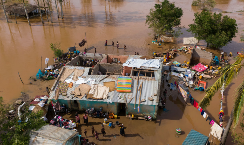
Flooding in Ghana is not a rare event; it is a recurring reality for millions. Multiple studies and disaster reports estimate that major flood events over recent decades have affected more than 4 million people nationwide. Annual disaster losses cost the country approximately GH¢300 million, with Greater Accra alone accounting for over GH¢200 million of that total. In 2025, the Western Regional Office of NADMO recorded 207 disasters, affecting more than 4,347 people.
Peer-reviewed research describes flooding as Ghana’s most common natural disaster and identifies Accra as the city with the highest flood incidence and some of the most severe impacts on lives and property. Researchers also noted an increasing trend in heavy rainfall days in Accra from 1980 to 2020, suggesting elevated future flood hazard risk if adaptation measures do not improve (Yin et al., 2022).
If those numbers sound abstract, here is the real meaning: choosing where to live in Ghana without checking flood risk can lead to property loss, displacement, or worse. This guide breaks down which districts flood most often, which areas generally carry lower risk, and what you can do to protect yourself.
Flood risk varies significantly across Ghana. Some districts sit on high ground with natural drainage, while others lie in floodplains or low-lying coastal zones. The difference between a safer neighborhood and a flood hotspot often comes down to elevation, proximity to rivers, and local drainage infrastructure. However, no area is completely immune – even elevated areas can experience flash flooding from blocked drains or extreme rainfall.
Most Flood-Prone Areas in Ghana
Ghana experiences three types of flooding: pluvial (flash floods in urban areas), fluvial (river floods), and coastal (tidal surges along the 550-kilometer coastline). The most flood-prone districts fall into one or more of these categories.
According to a parliamentary statement in June 2025, the identified flood-prone areas in Ghana are settlements along water bodies and urban areas such as Accra, Kumasi, Tema, Tamale, Cape Coast, and Sekondi Takoradi.
Greater Accra Region
Accra and its surrounding municipalities frequently experience flooding during the rainy seasons. On March 29, 2026, heavy rains submerged major roads and homes across the capital. Affected areas included Dansoman, Weija, Kasoa Old Barrier, Mallam Junction, Kaneshie, Accra Central, and Circle. In Tema Manhean, floodwaters forced the rescue of 14 children, with residents blaming blocked drains for the disaster.
Much of Accra’s recurring flood risk is tied to the Odaw River Basin, a major catchment that drains densely urbanized areas including parts of Ga East, Ga West, Accra Metropolitan, Adenta, and surrounding corridors. When rainfall exceeds drainage capacity, flooding can spread quickly across roads and neighborhoods (Osei et al., 2023).
A household survey in flood-prone Accra communities focused on Korle Gonno, Kaneshie, Accra New Town, Jamestown, Nima, Old Fadama, Adabraka, Agbogbloshie, and Abossey-Okai. These locations were selected because of repeated flood exposure, proximity to the Odaw River and Korle Lagoon system, or long-standing flood vulnerability.
A 2024 study found that 45.2 percent of the Greater Accra Metropolitan Area is prone to high flood risk, driven by population density, impervious surfaces, and proximity to water bodies. Low-elevation coastal areas like Weija-Gbawe and La-Nkwantanang-Madina are at particularly high risk.
| District / Municipality | Notable Flood Events |
|---|---|
| Accra Metro (Kaneshie, Circle, Adabraka, Asylum Down) | 2015 (152 deaths), 2025 (4 deaths, 3,000 displaced), March 2026 |
| Tema Metropolitan | March 2026 (14 children rescued), 2023 dam spillage impacts |
| Weija-Gbawe | Recurring flash floods, identified as high-risk in DEM analysis |
| Ga East / Ga West | Identified for demolition of unauthorized buildings contributing to flooding |
Ashanti Region (Greater Kumasi)
Kumasi faces severe flash floods during the major rainy season. In 2024, Kwabre East alone recorded at least 17 disaster cases linked to flooding, fire, and poor drainage. Municipalities such as Kwabre East and Asokore Mampong have been flagged as high-risk areas.
Kumasi flood risk is often driven by short, intense storms. Researchers studying a severe June 2018 flooding event found that it caused deaths and displacement, showing how rapidly urban flooding can develop outside Accra as well (Agyekum et al., 2023).
A 2024 study mapped flood vulnerability across 442 urban communities in the Greater Kumasi Metropolitan Area. The research found that built-up areas close to watersheds with lower elevations face the highest flood risk.
Volta Region (Riverine Flooding)
The 2023 Akosombo Dam spillage caused one of Ghana’s most devastating flood events in recent memory. Reports indicate that 177 communities across 9 districts were affected, displacing over 39,000 people. The hardest-hit districts included North Tongu, Central Tongu, South Tongu, Shai Osudoku, Asuogyaman, Anloga, Ada East, and Lower Manya, with Mepe in North Tongu among the most severely affected communities.
The spillage flooded communities downstream from the dam, destroying homes and farmland along the banks of the Volta River. Some communities were displaced into safe havens in Ada East, Central Tongu, North Tongu, and Shai Osudoku districts.
The investigation committee recommended designating a formal floodplain and preventing inhabitants from settling in these high-risk zones.
Northern Ghana (White Volta Basin)
Communities along the White Volta face recurring annual flood risk, typically around August and September, when torrential rainfall coincides with the spillage of Burkina Faso’s Bagre Dam. This annual flooding cycle has become a predictable disaster for Ghana’s northern regions.
Flood susceptibility mapping classified the White Volta Basin into five risk zones, with the Upper East Region’s Talensi District, Bawku West, and parts of Bolgatanga Municipal area showing the highest vulnerability. Communities such as Nunku, Tolla, Zaare, Pwalugu, Balungu, Winkongo, Biung, and Tongo are particularly exposed to inundation.
The 1999 floods in northern Ghana affected approximately 300,000 people, making it one of the country’s most significant flood disasters in recent decades. The 2007 floods affected over 300,000 people in northern Ghana. Contemporary reports also documented deaths, housing damage, and crop losses across multiple districts.
Bono Region
In May 2025, NADMO identified 78 flood-prone communities in the Bono Region. Specific high-risk areas include Banda-Ahenkro, Sunyani Central Business District, Sunyani Kuotokrom, and Berekum Municipality. A geospatial study of the Sunyani Municipality found that 21.32 percent of the area lies within highly flood-prone zones, with Abesim, Newtown, Nkwarbeng, Baakoniaba, Kootokrom, and Penkwase identified as the most vulnerable towns.
Central and Western Regions
Flooding in the Central Region forced over 5,700 households to evacuate in June 2025. Affected districts included Agona East, Agona West, Mfantseman, Mankessim, Komenda, Assin South, Dunkwa-On-Offin, Upper Denkyira East, Winneba, Gomoa East, and Awutu Senya West.
Cape Coast experiences coastal flood events combined with urban drainage issues. Sekondi-Takoradi faces frequent flooding due to rapid urbanization and massive encroachment of waterways. A 2025 study mapped flood hazards in the Sekondi-Takoradi Metropolis, confirming the area’s high flood vulnerability.
Lower-Risk Areas in Ghana (Historically Lower Reported Flood Exposure)
Flood risk is hyperlocal. No area is completely flood-free, but some districts and towns have historically experienced fewer major flood incidents than the hotspots listed above. These areas generally sit on higher elevation, away from major rivers and coastal flood zones.
Below are areas often cited by residents, real estate agents, and local planners as having lower relative flood risk. Always verify conditions on the ground – drainage quality, recent development, and road design can change local risk.
| Area / Town / Municipality | Region | Why It Is Considered Lower Risk |
|---|---|---|
| Asutifi North | Ahafo | Elevations from 650 to 1,400 feet; sits on a watershed feeding the Tano River; mountainous ridges create natural catchment that regulates water flow |
| Aburi (town) | Eastern | Located in the hills, well above sea level; elevation is a natural advantage |
| Dodowa | Greater Accra | Located on relatively high land; water flows away more easily than in Accra’s low basins |
| Oyibi | Greater Accra | Higher ground with limited development blocking water paths (though new construction may alter drainage) |
| Adenta (elevated sections) | Greater Accra | Many elevated sections are considered lower risk than central Accra flood basins, though drainage quality varies by neighborhood |
| Ashaley Botwe | Greater Accra | Proper drains in some areas and slightly higher elevation; local conditions vary |
| North Legon (higher elevation parts) | Greater Accra | Higher elevation sections are often viewed as lower risk, but local road drainage still matters |
| Haatso | Greater Accra | Well-planned parts of the area experience fewer reported flooding issues than low-lying corridors |
| Kwabenya | Greater Accra | Sits on a hill; rainwater flows away easily in most sections |
| Oyarifa | Greater Accra | Near the Aburi hills; good location and proper planning in some parts help protect it |
These areas are better understood as relatively lower-risk locations compared with major coastal floodplains, river corridors, and dense urban basins. However, no area is entirely flood-proof, and site-specific drainage conditions still matter.
Other areas with generally lower flood exposure include Sekyere Afram Plains (Ashanti, hilly terrain), Asunafo North (Ahafo, mixed forest-agriculture region with no large floodplains), Nkoranza South (Bono East, well-drained rivers), Gushegu (Northern, arid Sahel zone with low rainfall), Krachi Nchumuru (Oti, located away from major Volta tributaries), Berekum West (Bono, inland plains with small streams), and Upper Denkyira (Central, forest hills above coastal plains).
Important caveat: These areas have fewer nationally reported major flood incidents compared with hotspots such as Accra lowlands, Volta floodplains, and coastal corridors. However, localized flooding can still occur due to blocked drains, intense rainfall, or new construction. Always inspect a specific property after heavy rain.
What Causes Flooding in Ghana?
Flooding in Ghana is rarely a single-cause event. It usually results from a combination of natural factors and human actions.
Natural Causes
Ghana’s bimodal rainfall pattern brings two wet seasons to the south (April to July and September to November) and one long rainy season to the north (May to October). Peak rainfall in May and June often exceeds the capacity of natural and man-made drainage systems. The White Volta Basin floods annually when torrential rains combine with the spillage of Burkina Faso’s Bagre Dam.
Human Causes
Poor drainage systems are the single biggest contributor to urban flooding. Gutters clogged with plastic waste and debris cannot carry water away during heavy downpours. In Tema Manhean, residents blamed the March 2026 flooding on a major drain that had been blocked.
Academic research on Accra also links repeated flooding to informal and unplanned settlements, physically weak structures in vulnerable zones, and indiscriminate waste disposal that clogs already inadequate drainage systems.
Researchers note that recurring urban flooding is not only an engineering problem. Weak enforcement of planning rules, poor coordination between agencies, political interference, and underfunded infrastructure can allow known flood risks to persist for years (Asibey et al., 2022).
Building on waterways and floodplains is another major driver. NADMO has repeatedly warned against constructing structures on waterways or in waterlogged zones, calling it illegal and a significant threat to lives and property. In the Bono Region, NADMO expressed concern about structures and kiosks springing up in unauthorized places, blocking waterways in 12 administrative districts.
Unauthorized buildings in areas like Lakeside, Oforikrom, Ga East, Ga West, Kasoa, and Ofankor have been cited as major contributors to perennial flooding.
Climate change is accelerating flood risk. Rising temperatures, erratic rainfall, and environmental degradation are already overwhelming sanitation infrastructure and contaminating water sources. In his 2026 State of the Nation Address, President John Mahama warned about the “unforgiving impact of climate change on the national economy,” citing threats to food security and hydropower generation. Ghana launched the Climate Atlas in March 2026 to provide localized projections through 2050, helping planners anticipate future flood risks.
Rapid urbanization and land-use changes have also increased flood exposure. In the Greater Accra Metropolitan Area, almost half (45.2 percent) of the area is now prone to high flood risk, driven by population density, built-up spaces, and impervious surfaces.
Why Do People Still Live in Flood-Prone Areas?
Flood risk does not always lead people to move. Research in Accra found many households remain in flood-prone communities because they live close to work, have long-established social ties, depend on local economic activity, or believe infrastructure improvements are a better solution than relocation (Yin et al., 2022).
Studies in flood-affected Ghanaian communities found that many households adapt rather than relocate. Common responses include moving valuables onto elevated surfaces, temporary relocation during storms, raising foundations, using sandbags, and in some cases abandoning ground floors during the rainy season (Douglas et al., 2008).
Flood damage often continues long after the rain stops. Households may face cleaning costs, drying time, repair bills, lost workdays, and replacement of damaged furniture, appliances, or finishes after floodwaters recede (Ahadzie et al., 2021).
The same study found that households suffering higher past flood losses were more willing to evacuate than those who had experienced floods with lower personal losses. In simple terms, direct financial pain often changes risk decisions more than warnings alone (Yin et al., 2022).
Researchers recommended combining public education, affordable housing options, restrictions on new settlement in flood-prone zones, and infrastructure upgrades rather than relying on a single solution (Asibey et al., 2022).
Climate Change and Future Flood Risk
Climate projections for Ghana indicate worsening flood conditions. A 2025 study analyzing climate extremes in the Lower Volta Basin found that isolated extreme rainfall events have become more frequent since 2000, increasing flood and erosion risks for vulnerable coastal areas.
Under a moderate climate scenario, modeling suggests that by 2080, road exposure to flooding and associated damages may double relative to 2000 levels due to more frequent flood events. The government has directed ministries, departments, and agencies to incorporate Climate Atlas data into national development plans and local budgets, with engineers designing transport and water infrastructure expected to account for future flood risks.
Flood susceptibility mapping for the White Volta Basin classified the area into five risk zones, emphasizing that future vulnerabilities will be driven by both climate change and human factors. Disaster risk reduction and sustainable land-use planning are critical to managing these risks.
How to Check a Property for Flood Risk Before You Rent or Buy
Flood risk is not only about whether a house gets wet. Road access also matters. Studies in Accra found that certain transport corridors become dangerous or impassable during flood events, which can isolate neighborhoods even if the property itself sits on relatively higher ground (Osei et al., 2023).
Past flooding can leave clues even after the water is gone. Look for peeling paint, swollen doors, mold smell, damaged lower walls, cracked plaster, rusted gates, or replaced electrical outlets near floor level. These can indicate previous water intrusion (Ahadzie et al., 2021).
Some households in heavily affected areas eventually stop using ground-floor rooms during peak rainy periods. If a property shows signs that lower levels are regularly avoided or heavily reinforced, treat that as a serious flood-risk warning sign (Douglas et al., 2008).
- Ask neighbors how the area performed during the last heavy rains.
- Check whether the road sits at the bottom of a slope or collects standing water.
- Inspect nearby drains, streams, lagoons, or culverts.
- Look for water stains, mold, cracked walls, or repaired lower walls.
- Confirm whether access roads become blocked during storms.
- Check if nearby construction has altered natural water flow.
- Review local assembly guidance or NADMO alerts where available.
- If possible, visit the property after a heavy rain – this is the single best real-world test.
Even areas considered lower risk can have hyperlocal drainage problems, so property-level checks matter.
Quick Flood-Risk Heuristic
Use this simple guide when evaluating a location. It is not a substitute for professional advice, but it helps you ask the right questions.
| Higher Risk Indicators | Lower Risk Indicators |
|---|---|
| Near a lagoon, river, or stream | On a ridge or elevated ground |
| At the end of a downhill road (collects runoff) | Well-maintained, unblocked drains |
| Low-lying urban basin or drainage corridor (e.g., Circle and other flood-prone Accra corridors) | Elevated plot with natural slope away from buildings |
| Beside a blocked or undersized drain | Multiple road exits (not cut off by one low point) |
| Visible water pooling after light rain | No standing water even after heavy rain |
If a property has three or more high-risk indicators, reconsider or insist on a professional drainage assessment.
Flood Insurance and Due Diligence
Insurance terms vary, so ask your insurer directly whether flood damage, flash flooding, and stormwater damage are covered under the policy. Before purchasing property in a lower-risk area, verify:
- Does your policy cover flood damage from natural rainfall?
- Does it cover flash floods or only river flooding?
- What is the claims process after a flood event?
For renters, contents insurance may be available at a lower premium. Even in areas that rarely flood, extreme weather events are becoming more common. A small annual premium can save you from a total loss. If you are buying land, consider commissioning a topographical survey to understand exactly how water flows across the plot.
Flood Safety Tips from NADMO
Timely and accurate weather forecasts can reduce flood losses by improving early warnings, evacuation timing, and household preparation before severe rainfall begins (Agyekum et al., 2023).
Flood events can also disrupt basic services such as water and electricity. Households should keep backup drinking water, charged phones, flashlights, batteries, and power banks ready before major storms begin (Kayaga et al., 2020).
NADMO has activated rapid response teams nationwide to handle flood-related emergencies. Here are the key safety recommendations:
- Avoid driving during heavy downpours.
- Do not walk or drive through floodwaters; strong currents and limited visibility pose serious risks.
- Keep surroundings clean to prevent waste materials from entering water paths.
- Do not build on waterways or flood-prone areas.
- Participate in community clean-up activities to keep drainage channels clear.
- Stay informed through official weather reports from the Ghana Meteorological Agency.
- Secure loose structures and property against strong winds.
NADMO’s flood contingency plan includes three phases: preparedness (dredging, desilting, identifying safe havens and evacuation routes), response (search and rescue, clearing blocked waterways, evacuating victims), and recovery (restoring services, resettlement, and reconstructing damaged infrastructure).
Frequently Asked Questions
Which part of Accra does not flood?
No part of Accra is completely flood-free, but areas on higher ground generally have lower risk. These include elevated sections of Aburi (in the hills), Dodowa (high land), Adenta (where drainage works), Ashaley Botwe, North Legon (higher parts), Haatso, Kwabenya (on a hill), and Oyarifa (near Aburi hills). Always inspect the specific street and property after rain.
Is there a single safest region in Ghana for flooding?
No single region can be described as completely safest. In general, higher-elevation inland areas with better drainage tend to carry lower relative flood risk than major coastal plains, river floodplains, and dense low-lying urban basins.
How much does flooding cost Ghana annually?
Ghana loses approximately GH¢300 million every year to disasters, mainly floods, droughts, and related emergencies. In the Greater Accra region alone, flood losses exceed GH¢200 million annually.
Does the Volta River flood every year?
Communities along the Volta River face recurring flood risks, especially when the Akosombo Dam spills excess water. The 2023 spillage affected 177 communities across 9 districts and displaced over 39,000 people. The White Volta River also experiences annual flood risk between August and October.
Why do people stay in flood-prone areas?
Research from Accra suggests common reasons include proximity to jobs, established family and community ties, affordability constraints, and the belief that drainage or infrastructure upgrades can solve the problem without relocation (Yin et al., 2022).
What is NADMO doing to prevent floods?
NADMO has activated a Flood Contingency Plan that includes dredging and desilting of water basins, restoration of water basins through excavation, identification of safe havens and evacuation routes, activation of early warning systems, public sensitization, and prepositioning of resources. NADMO works with the Ghana Armed Forces, Ghana National Fire Service, Ghana Water Company, Ghana Hydrological Authority, Ghana Police Service, and the Ghana Meteorological Agency.
If you need legal assistance regarding property purchase, lease agreements, or due diligence in Ghana, consider reaching out to a qualified Ghanaian lawyer. Use the form below to get started:
Get the full relocation guide:
250 Things to Know Before Moving to Ghana
Sources
- Parliament of Ghana: “Recent Flooding Incidents Across the Country” (June 2025)
- GNA: “NADMO identifies 78 flood prone areas in Bono Region” (May 2025)
- GBC: “14 children rescued as floodwaters wreak havoc in Tema Manhean” (March 2026)
- The Herald: “Recurring floods hit Accra after overnight downpour” (March 2026)
- Graphic Online: “2023 Akosombo dam spillage: Committee recommends adequate compensation for victims” (May 2025)
- PMC: “Geospatial approach to pluvial flood-risk and vulnerability assessment in Sunyani Municipality” (September 2024)
- Scientific Reports: “Increased flooded area and exposure in the White Volta river basin” (2022)
- GhanaWeb: “Ghana loses GH¢300 million annually to floods – UNDP” (October 2025)
- GBC: “May 18 downpour: Four dead and 3,000 displaced – NADMO” (May 2025)
- GNA: “NADMO WR Records 207 Disasters in 2025” (February 2026)
- Yin, Q., Ntim-Amo, G., Xu, D., Gamboc, V.K., Ran, R., Hu, J., & Tang, H. (2022). Flood disaster risk perception and evacuation willingness of urban households: The case of Accra, Ghana. International Journal of Disaster Risk Reduction, 78, 103126. https://doi.org/10.1016/j.ijdrr.2022.103126
- Osei, J.D., Anyemedu, F.O.K., & Osei, D.K. (2023). Integrating 2D hydrodynamic, SWAT, GIS and satellite remote sensing models in open channel design to control flooding within road service areas in the Odaw river basin of Accra, Ghana. Modeling Earth Systems and Environment. https://doi.org/10.1007/s40808-023-01742-1
- Agyekum, J., Amekudzi, L.K., Stein, T., Aryee, J.N.A., Atiah, W.A., Adefisan, E.A., & Danuor, S.K. (2023). Verification of satellite and model products against a dense rain gauge network for a severe flooding event in Kumasi, Ghana. Meteorological Applications, 30, e2150. https://doi.org/10.1002/met.2150
- Douglas, I., Alam, K., Maghenda, M., McDonnell, Y., McLean, L., & Campbell, J. (2008). Unjust waters: climate change, flooding and the urban poor in Africa. Environment and Urbanization, 20(1), 187-205. https://doi.org/10.1177/0956247808089156
- Asibey, M.O., Mintah, F., Adutwum, I.O., Wireko-Gyebi, R.S., Tagnan, J.N., Yevugah, L.L., Agyeman, K.O., & Abdul-Salam, A.J. (2022). Beyond rhetoric: urban planning-climate change resilience conundrum in Accra, Ghana. Cities, 131, 103950. https://doi.org/10.1016/j.cities.2022.103950
- Kayaga, S.M., Amankwaa, E.F., Gough, K.V., Wilby, R.L., Abarike, M.A., Codjoe, S.N.A., Kasei, R., Nabilse, C.K., Yankson, P.W.K., Mensah, P., Abdullah, K., & Griffiths, P. (2020). Cities and extreme weather events: impacts of flooding and extreme heat on water and electricity services in Ghana. Environment and Urbanization. https://doi.org/10.1177/0956247820952030
- Ahadzie, D.K., Mensah, H., & Simpeh, E. (2021). Impact of floods, recovery, and repairs of residential structures in Ghana: insights from homeowners. GeoJournal, 87. https://doi.org/10.1007/s10708-021-10425-2