
The Volta River is the principal river system of Ghana, a waterway that shapes the country’s geography, energy supply, and livelihoods. The Volta system extends roughly 1,600 to 1,850 kilometers from headwaters in Burkina Faso and Benin to the Gulf of Guinea. Its basin spans six West African countries, and the Volta basin covers about 70 percent of Ghana’s land area and supports important agricultural, fishing, transport, and energy activities. The river is best known internationally for Lake Volta, the reservoir created by the Akosombo Dam in the 1960s, which remains the largest human-made lake in the world by surface area. The Volta River is not only a geographic landmark but also a critical resource for hydroelectric power, agriculture, fishing, and transportation in the region.
Location
Table of Contents
Overview
The Volta River is the major river system of Ghana, a complex network of waterways that drains a catchment area of approximately 154,400 square miles (400,000 square kilometers). The river derives its name from the Portuguese word for "meander" or "turn," a reference to its curved course that marked the furthest extent of Portuguese exploration along the West African coast. The river system is composed of several main branches, including the Black Volta, the White Volta, and the Red Volta, which converge as they flow southward through Ghana.
The river’s significance extends well beyond its physical presence. The Volta River Basin supports the livelihoods of a substantial portion of Ghana’s population, providing water for agriculture, fishing, and domestic use. The construction of the Akosombo Dam in the mid-1960s transformed the river into a major source of hydroelectric power, creating Lake Volta in the process. Akosombo was historically central to Ghana’s electricity supply, and hydropower sometimes provided most of the country’s generation. Its share has varied over time as Ghana added thermal and other generating capacity and as water levels changed. The river also holds cultural importance, with local names including Asuo Firaw in Akan and Amuga in Ewe, and the Akwamu people historically referred to the river as Firaw, dedicating a deity named Mfodwo to it.
Course and Geography
The Volta system extends roughly 1,600 to 1,850 kilometers from headwaters in Burkina Faso and Benin to the Gulf of Guinea, passing through varied landscapes that range from savanna grasslands in the north to rainforest patches in the southwest. The river’s course takes it along the Akwapim-Togoland highlands before it reaches the Atlantic Ocean. The upper reaches of the river system consist of numerous headwaters and streams that tend to be intermittent, particularly during the dry season, while the lower reaches evolve into permanent bodies of water.
The climate of the Volta River Basin is subhumid to semiarid, reflecting its location within the West African Savanna Zone. Rainfall varies significantly across the basin, with the southeastern area receiving more than three times the rainfall of the extreme northern area. Within the basin, approximately 70 percent of rain falls between July and September, and there is almost no rain between November and February. Year-round temperatures in the region typically range from 77 to 93 degrees Fahrenheit (25 to 34 degrees Celsius).
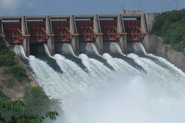
The river’s course is interrupted by the Akosombo Dam, which impounds Lake Volta. The reservoir extends about 400 kilometers northward from the dam to the Yapei area in Ghana’s Savannah Region. The lake has a total surface area of approximately 3,275 square miles (8,485 square kilometers). Below the dam, the river continues its journey to the sea, crossed by the Adomi Bridge just south of Akosombo.
Source and Mouth
The Volta system extends roughly 1,600 to 1,850 kilometers from headwaters in Burkina Faso and Benin to the Gulf of Guinea. The Black Volta rises in southwestern Burkina Faso, the White Volta begins as the Nakanbé in northern Burkina Faso, and the Oti begins as the Pendjari in Benin.
The river empties into the Atlantic Ocean at the Gulf of Guinea, at a mouth located near Ada Foah on Ghana’s southeastern coast. The coordinates of the river’s mouth are approximately 5°46′N 0°41′E. The Muni-Pomadze Ramsar Site is a separate coastal lagoon and wetland near Winneba, approximately 55 kilometers west of Accra. It should not be described as part of the Volta River basin or as being near the Volta estuary at Ada Foah. This coastal wetland is recognized as one of the most important coastal wetlands in the world and serves as a major breeding and nesting site for migratory birds.
Tributaries and Basin
The Volta River is fed by several major tributaries, most notably the Black Volta, the White Volta, and the Red Volta. The Oti River, which enters Ghana from Togo in the east, is another significant tributary. The Daka River and the Todzie River also contribute to the system. Both the Red and White Volta Rivers are greatly reduced in flow from January until the rains begin in May.
The Volta River Basin is a transboundary watershed shared by six countries. Approximately 42 percent of the basin lies within Ghana’s borders, while 43 to 45 percent lies within Burkina Faso. Smaller portions of the basin extend into Togo (6 percent), Benin (4 percent), Mali (3 percent), and Côte d’Ivoire (2 percent). The basin’s total catchment area is approximately 154,400 square miles (400,000 square kilometers).
The basin’s land habitats are varied, ranging from bush to rainforest and from wooded gorges to grassy plains. Great expanses of savanna border the major streams within the basin, varying from savanna grassland in the north to savanna woodland in the center and yielding to swaths of rainforest in the southwest. The conditions within the river are similar to those of the Niger River, which arcs across the northern reaches of the Volta catchment, and it is believed that the Black Volta may have originally been a tributary of the Niger.
Economic and Community Importance
The Volta River is central to the economy and daily life of Ghana. More than half of the labor force in Ghana is employed in agriculture and fishing, and the river system supports both activities. Farmers use the waters of the Volta and Lake Volta to irrigate their crops, while anglers depend on the river’s resources for their livelihoods. As the land of the Volta River Basin stretches inland from the coast, it becomes more arid, resulting in shorter growing seasons and more erratic rainfall, which makes the lake’s irrigation capacity particularly valuable.
The Akosombo Dam, built in the mid-1960s in partnership with a foreign company, created the Akosombo Hydroelectric Power Plant, which was originally commissioned with 912 megawatts of installed capacity and was later upgraded to 1,020 megawatts. The dam created Lake Volta, which is maintained chiefly for its ability to generate electricity. Akosombo was historically central to Ghana’s electricity supply, and hydropower sometimes provided most of the country’s generation. Its share has varied over time as Ghana added thermal and other generating capacity and as water levels changed. Lake Volta is also a major transportation and trade route, providing water transport connections between southern and northern Ghana.
During the 2000s and early 2010s, Ghanaian institutions and private companies developed a project to recover submerged timber from Lake Volta using sonar-guided equipment. Supporters presented it as a way to improve navigation and obtain timber without felling living forests, but later research has raised concerns about effects on fishing livelihoods and access to the lake.
The population of the Volta River Basin has grown rapidly over recent decades. The United Nations reported twenty-nine million people living in the area in 2023. The countries sharing the basin generally have high poverty rates and economies that remain undeveloped, and there is widespread use of unsustainable agricultural methods that result in significant environmental degradation.
Environmental Context
The Volta basin supports diverse fish and other aquatic fauna, including species adapted to strong seasonal changes in flow. Mammals within the ecoregion include the marsh mongoose, African clawless otter, spot-necked otter, hippopotamus, and West African manatee, the last of which is considered vulnerable.
Dams, altered flooding patterns, fishing pressure, habitat degradation, invasive species, and pollution have changed aquatic communities in parts of the basin.
The Volta River Basin faces several environmental challenges. Biodiversity is decreasing, fishing and groundwater resources are being depleted, increased flooding is a major concern, and pollution from agricultural, industrial, and municipal sources is on the rise. Overpumping of the river’s waters has been a major issue. The Volta Basin Authority’s institutional framework was approved in July 2006; the six heads of state signed the establishment convention on January 19, 2007, and the convention entered into force in 2009. Water management in the basin requires coordination among all six riparian countries because dams, irrigation, flood control, hydropower, environmental protection, and downstream livelihoods can create competing demands.
Efforts are underway to promote sustainable practices in the basin. The recovery of submerged timber from Lake Volta is one example of combining economic activity with environmental stewardship. Studies have also examined the hydrogeological characteristics of the basin, including the White Volta River Basin, to better understand groundwater resources and support sustainable development.
Related Places
Several notable places are associated with the Volta River. Lake Volta, the reservoir created by the Akosombo Dam, is the largest human-made lake in the world by surface area and extends from the dam in southeastern Ghana to the Yapei area in Ghana’s Savannah Region. The Akosombo Dam itself is a major infrastructure landmark on the lower Volta River. The Adomi Bridge crosses the Volta River just below the Akosombo Dam, providing an important road link across the river.
Ada Foah, located at the river’s mouth, is a coastal town where the Volta meets the Gulf of Guinea. The Muni-Pomadze Ramsar Site is a separate coastal lagoon and wetland near Winneba, approximately 55 kilometers west of Accra. It should not be described as part of the Volta River basin or as being near the Volta estuary at Ada Foah. The country of Burkina Faso was formerly called Upper Volta, after the river, reflecting the river’s historical and geographic significance beyond Ghana’s borders.
Related Entries