
Quick links (related guides):
Table of Contents
- Top Hiking Locations Compared
- Detailed Guide to Each Hiking Spot
- How to Get There
- Cost of Hiking in Ghana
- Safety When Hiking in Ghana
- Animals You May Encounter
- Best Hiking Gear for Ghana
- Hiking Packing Checklist
- 2-Day Hiking Itinerary
- What to Do in an Emergency
- Official Governing Body
- Hiking Clubs & Groups
- FAQs
- Sources
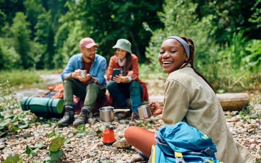
Most people do not expect hiking in Ghana to be physically demanding. That assumption is usually wrong. The real challenge is not altitude. It is heat, humidity, and terrain that drains energy faster than expected. Even relatively short hikes can feel much longer because the body is constantly working against the climate.
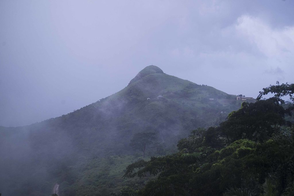
Halfway up Mount Afadjato, most people stop talking. That is when the hike really begins. Clothes are soaked, pace slows, and you realize quickly that preparation matters more than confidence. Many first-time hikers underestimate how quickly the heat builds up, especially in forested areas with limited airflow.
Before heading out, review the Ghana safety guide so you understand both the environment and the expectations. For official tourism information, the Ghana Tourism Authority maintains current guidance on most of the sites covered in this article.
Top Hiking Locations Compared
| Location | Coordinates | Elevation | Distance (Round Trip) | Avg Time | Difficulty | Safety | Best For |
|---|---|---|---|---|---|---|---|
| Mount Afadjato | 7.1500 N, 0.3500 E | 885 m / 2,904 ft (cited on signage; see note) | ~1.5-2 miles | 2-4 hours | Moderate | 8/10 | First-time serious hike |
| Wli Upper Falls | 7.1000 N, 0.5833 E | ~300 m / 985 ft terrain elevation | ~7 km / ~4.3 miles | 4-8 hours | Hard | 7/10 | Adventure hikers |
| Mount Gemi | 6.8549 N, 0.4334 E | 760 m / 2,493 ft | ~1-1.5 miles | 1-2 hours | Easy to Moderate | 9/10 | Views and photography |
| Shai Hills | 5.9064 N, 0.0597 E | Up to 243 m / 797 ft | ~1-3 miles | 2-4 hours | Easy to Moderate | 9/10 | Beginners / Accra day trips |
| Tagbo Falls | 7.1378 N, 0.3265 E | ~400 m / 1,300 ft; falls drop: 60 m | ~3 km / ~2 miles | 1.5-2 hours | Easy | 9/10 | Combining with Afadjato |
Important: Elevation is not the main challenge when hiking in Ghana. Heat and humidity make these trails feel harder than similar elevations in cooler climates.
Detailed Guide to Each Hiking Spot
Mount Afadjato
Mount Afadjato is the most visited hiking destination in Ghana, located in the Volta Region near the village of Liati Wote. It is widely promoted as Ghana’s highest mountain, though modern surveys dispute this and place the true high point further east at Leklata. For most hikers, that distinction is academic. The summit offers clear views of Lake Volta, neighboring villages, and Togo on days when Harmattan haze is not present.
The trail is clearly marked and local guides are available at the visitor centre in Liati Wote. The hike is accessible to reasonably fit beginners, but the steep incline and humidity combine to drain energy faster than expected. Most hikers need several rest stops on the way up.
One timing note that is often missed: the official Visit Ghana site states that the mountain “has little shade so it is best hiked in the early morning or late afternoon.” Most guides on the ground recommend starting before 7 AM. Starting in the early afternoon is inadvisable and increases the risk of descending in low light.
Also worth knowing: during the Harmattan season (November to March), summit views are generally poor due to haze. Visit Ghana explicitly notes this. If panoramic views are your main goal, plan around it or manage expectations.
How the visitor centre works: On arrival in Liati Wote, go directly to the community tourism office before starting either hike. Entry fees and guide fees for both Afadjato and Tagbo Falls are paid here. Guides are assigned by the office rather than chosen individually. There is a registration process before setting out. The office operates on cash only – no card facilities and no ATMs within a significant radius of the village. Withdraw cedis in Hohoe or Accra before making the journey.
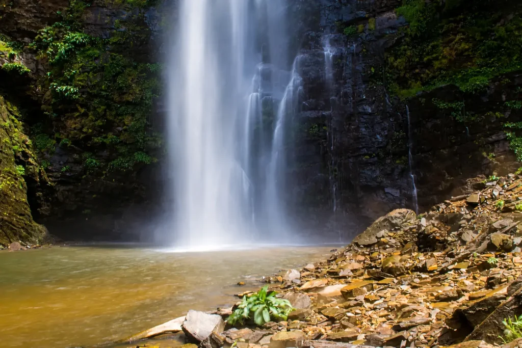
Tagbo Falls
Tagbo Falls is one of the most rewarding and most overlooked stops in the Liati Wote area. A 60-metre waterfall cascading in stages into a swimmable pool, it is reached by a 45-minute shaded walk from the same visitor centre used for Afadjato. The trail passes through coffee and cocoa farms and forest that records over 300 butterfly species. Swimming in the pool at the base is a genuine highlight, especially after the Afadjato climb. Many hikers do both in the same morning: summit Afadjato at sunrise, then cool off at Tagbo on the return. A separate trail fee applies at the tourism office. There are no food or water resupply points on either trail – bring everything you will need before leaving the village.
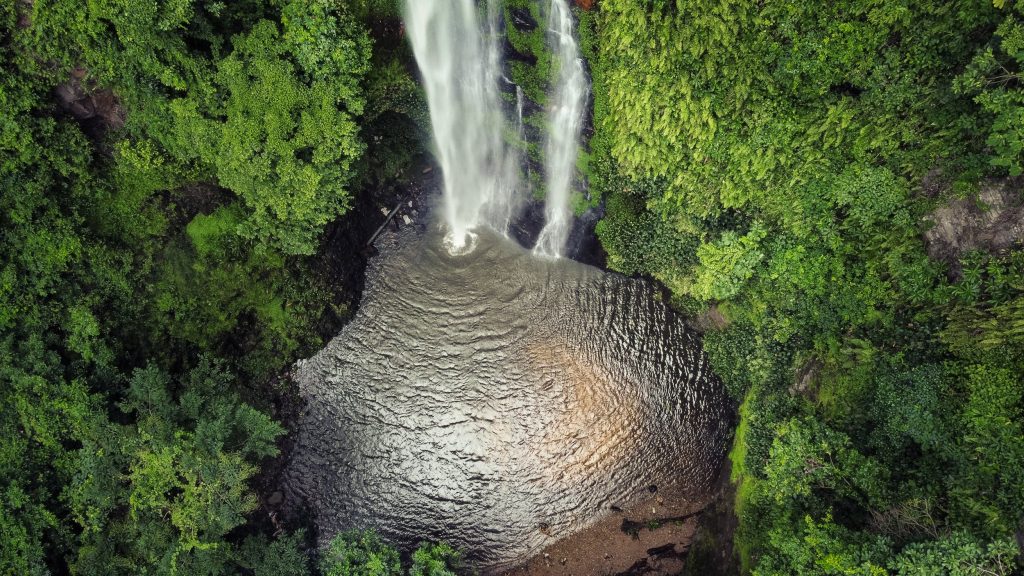
Wli Waterfalls (pronounced “Vlee”)
Wli Waterfalls – pronounced “Vlee,” not “Wlee” – sits within the Agumatsa Wildlife Sanctuary near Hohoe and is considered the highest waterfall in West Africa. It has two entirely different experiences: the lower falls, which are easy and accessible to almost anyone, and the upper falls, which are a serious hike that should not be underestimated.
The lower falls require a mostly flat 40-minute walk through the forest, crossing river points on wooden bridges. This is where a large colony of fruit bats roost on the cliffs – one of the most dramatic wildlife features in Ghana. Most visitors stop here. That is a reasonable choice.
The upper falls are a different matter. The official Wli Waterfalls tourism site states the upper falls hike takes 6-8 hours return. The trail becomes unmarked in sections, the terrain is steep, and wet conditions make the descent genuinely risky. A guide is required. There are no water sources you can drink from on the trail, and no food stops – carry everything from the entrance. After heavy rain, the upper route is sometimes closed or strongly discouraged by staff. Check conditions at the reception desk before committing to the upper route. Start no later than 7-8 AM.
Mount Gemi
Mount Gemi is located near Amedzofe, Ghana’s highest-elevated settlement, in the Volta Region. It offers some of the best panoramic views in the country with a shorter and less physically demanding hike than Afadjato. The area also has a canopy walkway that sees far fewer visitors than Kakum National Park. For moderate hikers who want a mountain experience without the full commitment of Afadjato, this is a strong alternative.
Shai Hills Resource Reserve
Shai Hills operates differently from the Volta Region hiking sites and is worth understanding before you go. It is a formal protected area covering approximately 51 square kilometres, managed by the Wildlife Division of Ghana’s Forestry Commission. Entry fees vary by nationality – Ghanaians, ECOWAS citizens, and non-African foreigners each pay different rates, with additional fees for vehicles. Opening hours are daily 8:00 AM to 5:00 PM.
The reserve is home to olive baboons, kobs, bushbucks, green monkeys, monitor lizards, and over 150 bird species. Hiking options include rocky hill trails and historic Shai caves – notably Sayu Cave and Adwuku Cave, which require climbing over rock formations, using ropes, and in places a ladder. A guide is required for cave sections and strongly recommended for all trails; guides are hired at the entrance gate. The terrain is rocky and uneven rather than muddy, but sturdy shoes are still necessary.
One important practical note: the baboons at Shai Hills are wild and can be aggressive, particularly if you are carrying food visibly. Do not feed them under any circumstances.
The reserve is approximately 50 km from Accra via the Accra-Tema-Akosombo highway, roughly a one-hour drive. By public transport, take a trotro toward Akosombo and alight at Doryumu Junction, then take a taxi from there.
How to Get There
Most major hiking locations are in the Volta Region. The drive from Accra to Liati Wote – the base for Afadjato and Tagbo Falls – is approximately 200 km and typically takes 4-6 hours depending on traffic and road conditions. Wli is roughly 280 km from Accra and adds 30-45 minutes from Liati Wote once in the region.
Transport options include trotros for budget travel (Tudu Station to Hohoe, then onward by local taxi or motorbike), private hire cars for flexibility, and organized tour groups. See the full Transportation in Ghana guide for detail on each option.
Cash: There are no ATMs within a significant distance of most trailheads in the Volta Region. The Liati Wote tourism office operates on cash only. Withdraw cedis in Accra or Hohoe before continuing to hiking areas.
Offline maps: Google Maps is often inaccurate outside Ghana’s cities, and mobile signal disappears in forested areas. Before leaving Hohoe, download an offline map of the Volta Region. OsmAnd (Android and iOS) uses OpenStreetMap data, works fully offline, and includes trail paths that Google Maps does not show. Google Maps also supports offline downloads for specific areas – use this as a backup. Download both before you lose signal, not after.
Cost of Hiking in Ghana
Hiking in Ghana is relatively affordable. Below are approximate costs based on current information. Prices are shown in Ghana Cedis (GHS), US Dollars (USD), British Pounds (GBP), and Chinese Yuan (RMB). Exchange rates as of March 2026: 1 USD = approx. GHS 10.85, GBP 0.75, RMB 7.25. Rates fluctuate – verify before travel at XE.com or the Bank of Ghana.
| Item | GHS (approx.) | USD (approx.) | GBP (approx.) | RMB (approx.) | Notes |
|---|---|---|---|---|---|
| Afadjato entry fee | GHS 20-55 | USD 2-5 | GBP 1.50-3.75 | RMB 14-36 | Paid at Liati Wote visitor centre; cash only; confirm on arrival as fees change |
| Tagbo Falls entry fee | GHS 20-55 | USD 2-5 | GBP 1.50-3.75 | RMB 14-36 | Separate fee from Afadjato, paid at same visitor centre |
| Wli Falls entry (lower falls) | GHS 30-65 | USD 3-6 | GBP 2.25-4.50 | RMB 22-43 | Paid at Agumatsa sanctuary reception; upper falls may carry additional guide fee |
| Shai Hills entry (foreigners) | GHS 65-110 | USD 6-10 | GBP 4.50-7.50 | RMB 43-72 | Rates differ for Ghanaians, ECOWAS citizens, foreigners; vehicle fee applies separately |
| Guide fee (standard hike) | GHS 100-200 | USD 9-18 | GBP 7-14 | RMB 65-130 | Guides at community sites rely primarily on tips; tip generously |
| Accommodation (Hohoe area) | GHS 200-380 | USD 18-35 | GBP 14-26 | RMB 130-254 | Ranges from basic guesthouses to eco-lodges near Liati Wote |
All prices are approximate and subject to change. Exchange rates are indicative only, based on mid-market rates as of March 2026 (source: XE.com). Verify current rates before travel.
Safety When Hiking in Ghana
Hiking in Ghana is generally safe. The main risks are not crime – they are dehydration, heat exhaustion, and navigation. Trails in the Volta Region are often unmarked. Mobile signal drops quickly once you leave main roads, and in some forested sections it disappears entirely. There are no water sources on these trails that are safe to drink from without treatment, and no food or supply stops once a hike begins. Carry everything from the trailhead.
Hiking with a guide reduces risk significantly. For the Wli upper falls specifically, a guide is required and this is a sensible rule: the trail becomes ambiguous in several places, and the descent is where most falls occur. On wet days, some sections of the upper route become genuinely hazardous, and staff may discourage or prevent access after heavy rain.
Offline maps: Download OsmAnd or a Google Maps offline region before leaving Hohoe. GPS works on your phone even without mobile signal – your location will still appear on a downloaded map even when you have no data connection. This is one of the most practical steps a first-time hiker in Ghana can take.
Emergency numbers in Ghana:
- Police: 191
- Ambulance: 193
- Fire: 192
- General emergency: 999
What to Do in an Emergency
Most hiking emergencies in Ghana are slow problems that get worse because people are unprepared. The most common issues are dehydration, exhaustion, disorientation on unmarked paths, and slipping on wet terrain.
If you get lost, do not keep moving blindly. That is how people end up farther from the main trail. Stop, retrace your last known point, and listen for human activity. In most hiking areas around the Volta Region, villages are closer than they feel.
If someone in your group is overheating, stop immediately. Find shade, reduce movement, and start rehydrating. Heat exhaustion builds quietly and hits fast in Ghana’s climate.
Treat your phone as a limited resource from the start. Enable low power mode before the hike begins, not when the battery drops to 10 percent. Even without signal, your phone remains essential for GPS navigation and emergency contact when signal returns.
Animals You May Encounter
Large dangerous animals are not a concern on common hiking routes in Ghana. The more relevant issue is smaller, persistent environmental exposure.
Monkeys – including Mona and spot-nosed species – are common in the Volta Region forest. They will approach if you hold food. Do not feed them or try to interact. At Shai Hills, the situation is more serious: the olive baboons there are wild and can be aggressive, particularly toward anyone carrying food visibly. Keep snacks inside a bag and do not approach them.
The fruit bat colony at Wli lower falls is one of the most dramatic wildlife sights in Ghana. Thousands of bats roost on the cliffs above the falls. They are harmless at a distance, but the ground around them is often slippery and wet. Timing a late-afternoon visit to watch the bats take flight to feed is a highlight many visitors miss entirely.
Snakes exist throughout the region, but sightings on well-used trails are rare. In practice, insects are a far greater nuisance. Mosquitoes are persistent in forested and wet areas. Stinging nettles are also present on sections of the upper Wli trail, so long pants are advisable for that route.
Best Hiking Gear for Ghana
Most gear advice online is written for cooler climates. Ghana is different, and those differences change what actually matters.
Footwear is the most important decision. Trails in the Volta Region can shift from dry dust to wet clay within minutes. Shoes that lose grip make everything harder and more dangerous – this is especially true on the descent of the Wli upper trail. Standard sneakers are inadequate for anything beyond Shai Hills and the Wli lower falls walk.
Water is not optional. It is the difference between finishing a hike comfortably and struggling through the second half. Many hikers run out because they assume the hike is short. A hydration pack is better than a water bottle – it allows consistent drinking rather than rationing. Critically, there are no streams or sources on any of these trails that are safe to drink from without treatment equipment. What you carry in is what you have.
A power bank is one of the most overlooked items. Background processes drain batteries faster in heat. Losing phone function in a remote area removes your navigation, communication, and backup plan simultaneously. Enable low power mode before the hike starts.
For the Wli upper falls, add a waterproof bag or dry bag. Spray from the falls and river crossings will reach gear.
Hiking Packing Checklist
- Water (more than you think): Dehydration is the biggest risk. There are no safe water sources on any of these trails. What you carry in is what you have for the entire hike.
- Hiking shoes with grip: Trails become slippery quickly, especially after rain. Non-negotiable for Wli upper falls. Essential for anything beyond Shai Hills and Wli lower falls.
- Insect repellent: Mosquitoes are persistent in forested areas. Long pants help on the upper Wli route where stinging nettles are present.
- Snacks: There are no food stops once most hikes begin. Simple energy snacks help maintain stamina, particularly on longer routes like Wli upper falls.
- Power bank: Mobile signal drops in remote areas, but the phone remains essential for GPS navigation and emergency contact. Enable low power mode from the start.
- Offline map downloaded: Download OsmAnd (free, uses OpenStreetMap data) or a Google Maps offline region before leaving Hohoe. GPS works without signal – your location still shows on a downloaded map.
- Waterproof bag or dry bag: Important for Wli upper falls where spray and sudden rain are common.
- First aid kit: Cuts, blisters, and insect bites are common. Minor issues can become larger problems in heat and humidity without basic supplies.
- Swimsuit: Tagbo Falls and Wli lower falls both have pools worth swimming in. One of the best parts of either hike.
- Cash in cedis: No ATMs near most trailheads. Withdraw before leaving Hohoe or Accra.
2-Day Hiking Itinerary (Realistic Plan)
This is the most practical and commonly recommended route for hiking in Ghana. It combines Mount Afadjato, Tagbo Falls, and Wli Waterfalls in a way that works logistically, not just on paper. All three are in the same region.
Day 1: Accra to Volta Region – Mount Afadjato and Tagbo Falls
Leave Accra early – ideally between 5:30 and 6:30 AM. The drive to Liati Wote is approximately 200 km and takes around 4-6 hours depending on traffic and stops. Expect delays leaving Accra and slower roads past Hohoe.
On arrival in Liati Wote, go directly to the community tourism office. Entry and guide fees for both Afadjato and Tagbo Falls are paid here, and guides are assigned before either hike begins. The office is cash only. Start the Afadjato hike as early as possible – Visit Ghana recommends early morning when the mountain has little shade and temperatures are lower. The hike takes 2-4 hours round trip. Take your time on the ascent.
After descending, walk to Tagbo Falls from the same trailhead. The shaded 45-minute path through coffee and cocoa farms is a natural recovery from the climb. The pool at the base of the 60-metre falls is swimmable and genuinely refreshing. Allow 1.5-2 hours total for Tagbo.
Stay overnight in Liati Wote or nearby Hohoe. Accommodation ranges from basic guesthouses to eco-lodges (approximately GHS 200-380 / USD 18-35 / GBP 14-26 / RMB 130-254 per night). Do not attempt to drive back to Accra the same day.
Day 2: Wli Waterfalls – Lower and Upper Falls
Start early – no later than 7-8 AM if doing the upper falls. Wli is about 30-45 minutes from Liati Wote by road. Remember: Wli is pronounced “Vlee.”
The lower falls are a flat 40-minute walk and suitable for almost any fitness level. The fruit bat colony at the cliffs is worth spending time with. Most visitors stop here. That is a reasonable choice.
If continuing to the upper falls: before committing, check conditions with staff at the reception desk. After heavy rain the route is sometimes closed or strongly discouraged. Assuming conditions are good, the official Wli Waterfalls tourism site puts the round trip at 6-8 hours. A guide is required. Bring all water and food from the entrance – there are no resupply points on the route. Bring a waterproof bag and footwear with solid grip. The descent, not the ascent, is where most falls occur.
Finish by early afternoon, rest, and begin the drive back to Accra. Expect to arrive in the evening.
Important: This itinerary works because all three locations are in the same region. Adding other sites to a two-day schedule typically results in rushed hiking or incomplete routes.
Official Governing Body: Ghana Mountain and Trail Federation
In September 2024, the Ghana Mountain and Trail Federation (GMTF) was inaugurated under the umbrella of Ghana Athletics. This is the official body now responsible for developing mountain running, trail running, and organised trail events across the country.
If the name sounds formal, here is the real meaning: Ghana now has a recognised federation aligned with World Athletics to structure mountain and trail disciplines as official sports. This moves outdoor recreation beyond informal hobby groups into a framework with safety standards, competitions, and coordinated development.
The federation operates autonomously but works closely with Ghana Athletics. Its responsibilities include organising road races, marathons, cross-country events, and mountain competitions. Leadership includes Christopher Darko-Amankrah as President, Danyagri Clement Smith as Vice President, and Moro Salifu as General Secretary. The federation has already surveyed the Dodowa and Larteh mountains as potential event locations.
For hikers, this matters because a formal federation signals growing infrastructure, potential for guided events, and increased attention to trail maintenance and safety standards.
Hiking Clubs & Groups in Ghana
Ghana’s hiking community is welcoming but decentralised. Most groups operate through social media or word-of-mouth, and there is no single public calendar for all hikes. The table below lists the most active clubs. After the table, you’ll find details on how each group works and how to connect with them.
| Club / Organization | Key Focus / Vibe | Location | Contact Information | Key Detail |
|---|---|---|---|---|
| Ghana Hiking Group | Free, community-based day hikes for all levels including family, standard, and adventure hikes | Accra | Email: ghanahiking@gmail.com; Facebook page available | Open to all; hikes range from family-friendly with BBQs to demanding unexplored routes |
| Tsenku Hiking Club | Local hiking club operating on Saturdays | Obosomase, Eastern Region (Address: VR8W+HM5) | Phone: +233 24 463 6430 | Open Saturdays 6:00 AM to 12:00 PM; listed on travel platforms with limited reviews |
| Kupanda Expeditions | Challenging jungle expeditions and mountaineering with four difficulty levels | Based online (Clubhouse platform) | Clubhouse: @kupanda-expeditions | Organizes approximately 4 expeditions per year; Level Three involves 10+ hours of mountaineering with pack and tent |
| Ghana Scout Association | Traditional scouting with camping, hiking, and community service programs | Nationwide with headquarters in Accra | Website: ghanascout.org; membership applications available online | Founded in 1912; membership approximately 23,739 Scouts nationwide; hiking is a core program activity |
Ghana Hiking Group
Based in Accra, this group describes itself as a small community of Ghanaians and expatriates. They organise three types of hikes: family hikes on easy, child-friendly routes (often with BBQs), standard hikes on established moderate trails, and adventure hikes on demanding, sometimes unexplored routes. All hikes are free. To join, email ghanahiking@gmail.com or follow their Facebook page for announcements. No regular calendar is published – you need to reach out directly.
Tsenku Hiking Club
Located in Obosomase in the Eastern Region, this club operates every Saturday from 6:00 AM to 12:00 PM. Multiple travel platforms list it as an official attraction, though no verified reviews are currently available. The address (VR8W+HM5) suggests a physical meeting point. Contact them by phone at +233 24 463 6430 to confirm details before visiting.
Kupanda Expeditions
This group focuses on serious jungle expeditions designed to test mental and physical limits. They operate mainly through the Clubhouse social audio platform. Expeditions are divided into four difficulty levels; Level Three requires participants to carry backpacks and tents while mountaineering for 10 hours or more. Approximately four expeditions are organised per year. Join their Clubhouse group @kupanda-expeditions to follow announcements.
Ghana Scout Association
As Ghana’s national Scouting organisation, the Ghana Scout Association has operated since 1912. It offers structured programmes in leadership, community service, and practical skills, with camping and hiking as core activities. Membership is open to youth and adults; applications are available on their official website. Membership fees apply and cover uniforms and materials.
How to Find Hikes
Because most groups do not maintain public event calendars, the most reliable way to join a hike is to contact them directly via the provided email, phone number, or social channels. If you prefer a more structured experience, commercial tour operators also offer guided hiking packages – these can be a good option for visitors seeking private or scheduled outings.
FAQs
Is hiking in Ghana safe for foreigners?
Yes, with some qualifications. Popular areas like the Volta Region and Shai Hills are generally safe during the day. The real risks are terrain, weather, and navigation – not crime. Trails are often unmarked, mobile signal drops quickly outside main roads, and heat builds faster than most people expect. Stick to known routes, avoid hiking alone in remote areas, and carry more water than you think you will need.
Do you actually need a guide in Ghana?
In most cases, yes. Not because Ghana is dangerous, but because it is easy to get lost. Many routes are not formally mapped, and paths used by locals are not obvious to outsiders. A guide also helps with language in rural villages and can handle logistics. For the Wli upper falls, a guide is required – the trail becomes ambiguous in multiple sections. At Shai Hills, guides are hired at the entrance and required for the cave sections.
Is Afadjato really the highest point in Ghana?
This is genuinely disputed. The 885 m figure appears on local signage, but modern topographic surveys place the actual summit closer to 587 m. Nearby peaks Aduadu and Leklata are measurably higher, and Leklata is identified by multiple sources as Ghana’s true high point. Visit Ghana now refers to Afadjato as “one of the highest mountains” rather than the highest. For the practical hiking experience, the debate changes nothing – the trail and the effort are the same.
What are the biggest mistakes first-time hikers make in Ghana?
Underestimating the environment is the most common one. Heat, humidity, and sudden rain hit harder than people expect. Relying on Google Maps is another – it is often inaccurate outside cities. Not downloading offline maps before losing signal, not bringing enough water, not wearing proper footwear for muddy terrain, and starting Afadjato too late in the day also appear regularly. For Wli, underestimating the upper falls duration is consistent: 3-5 hours is not enough time. Plan for 6-8 hours.
What is the best time of year for hiking in Ghana?
The dry season (November to March) makes trails easier to navigate and reduces the chance of heavy rain. However, there is a tradeoff: Harmattan haze during this period significantly reduces visibility at summit viewpoints. If summit panoramas matter, the shoulder months of October-November or March-April tend to offer cleaner air and more manageable trail conditions. The rainy season (April to October) brings waterfalls to full volume but makes some trails slippery and the upper Wli route more hazardous – staff may restrict access after prolonged rain.
Are there dangerous animals to worry about?
Not on common hiking routes in general, but Shai Hills is an exception worth noting. The olive baboons there are wild and can behave aggressively if they see food. Keep snacks inside a bag and do not approach them. On the Volta Region trails, snakes exist but sightings are rare. Insects are a far greater practical concern – mosquitoes are persistent in forested areas, and stinging nettles appear on sections of the upper Wli trail. The fruit bat colony at Wli lower falls is dramatic but poses no danger.
If you need legal assistance related to residency, permits, or establishing outdoor businesses in Ghana, consider reaching out to a qualified Ghanaian lawyer. Use the form below to get started:
Sources
- Visit Ghana (Ghana Tourism Authority) – Mount Afadja
- Visit Ghana (Ghana Tourism Authority) – Liati Wote and Tagbo Falls
- Official Wli Waterfalls Tourism Site
- Wikipedia – Mount Afadja
- Wikipedia – Tagbo Falls
- Peakbagger – Afadjato elevation data
- Shai Hills Resource Reserve – entry fees, wildlife, and logistics
- OsmAnd – offline maps for Android and iOS
- XE.com – exchange rates (March 2026)
- Ghanaian Times: “GA inaugurates Ghana Mountain & Trail Fed.” (September 15, 2024)
- Clubhouse Database: Kupanda Expeditions Profile
- Ghana Scout Association Official Website
Compliance note: All money transfer services must be licensed by the Bank of Ghana.