
Tamale, Ghana is the capital city of the Northern Region and the country's third largest city by population. As the administrative and economic hub of northern Ghana, Tamale serves as a gateway to the region's rich cultural heritage, including the historic Kingdom of Dagbon. With a 2021 census population of 374,744, the city has grown rapidly from a modest colonial administrative post into a bustling metropolis that anchors commerce, education, and healthcare for millions of Ghanaians living in the northern savanna.
Location
Table of Contents
History
Tamale's origins trace back to a cluster of small villages that fell under the authority of the Kingdom of Dagbon, one of Ghana's oldest traditional states. The area was a known destination for cattle trails in the region, reflecting its early role as a meeting point for herders and traders moving through the northern territories.
The city's modern trajectory began in 1907, when British colonial authorities decided to establish administrative headquarters in the area. This decision came after German officials had taken over Yendi, prompting the British to seek a new seat of power in the north. The Dakpema, a local chief, assisted the British in this effort. A pivotal moment came in 1920 with the construction of a road nicknamed the "Great North Road," which connected Tamale to southern Ghana and transformed the settlement into an important center of business in the Northern Territories.
Throughout the 20th century, Tamale's population grew rapidly as people moved to the area seeking reliable water supply and electricity. This influx placed pressure on land, with large amounts of farmland converted to infrastructure. During this period, a series of disputes arose between the Gulkpe Na, one of the seven district chiefs in Dagbon who oversees local chiefs in and around Tamale, and the Dakpema over political power. These tensions were partly fueled by the British system of indirect rule, which created an imbalance of power between the chiefs. Although local councils were later introduced and indirect rule discontinued, friction between the chieftaincy factions has persisted.
In 1960, Tamale became the capital of the Northern Region after the region was separated from the rest of the north. This administrative status cemented the city's importance as the political and economic center of northern Ghana.
Geography
Tamale is located in the Tamale Metropolitan District, which sits in the central part of the Northern Region. The metropolis lies between latitude 9.16° and 9.34° North and longitudes 0.36° and 0.57° West, at an elevation of approximately 151 meters above sea level. The topography is generally rolling, with some shallow valleys that serve as stream courses and a few isolated hills that do not inhibit physical development.
The Tamale Metropolitan District shares boundaries with the Savelugu Municipality to the north, the Yendi Municipal Assembly to the east, the Tolon District to the west, the Central Gonja District to the southwest, and the East Gonja Municipal to the south. The district was elevated to metropolitan status in 2004.
Tamale experiences a tropical savanna climate, classified as Aw under the Köppen climate classification. The city typically has one rainy season per year, which affects staple crop farming. The rainy season brings heavy thunderstorms with limited sunshine in between. Mean monthly rainfall is about 89 mm, spread across roughly 95 days of tropical showers. Average monthly temperatures hover around 34°C, with minimum monthly temperatures near 23°C. Relative humidity is lowest between December and March at about 30 percent and highest around August at approximately 70 percent.
Climate change poses growing challenges for Tamale residents. Droughts, floods, and heatwaves have become more common, threatening farmers who depend on consistent rainfall for their crops. National policies and interventions from nongovernmental organizations aim to minimize the impact of climate change on the area.
People and Culture
Tamale is traditionally inhabited by the Dagomba people, and the city remains the cultural heart of the Dagbon Kingdom. Other ethnic groups resident in the city include the Gonja, Mamprusi, Nanumba, Konkomba, and Akan peoples, as well as groups from the Upper East Region such as the Dagaaba. This diversity reflects Tamale's role as a magnet for migration from across northern Ghana.
The 2010 census recorded that 90.5 percent of Tamale's population was Muslim, with Christians, spiritualists, and practitioners of traditional African religions making up the remainder. The city's Islamic heritage is visible in its architecture, festivals, and daily rhythms, though people of all faiths live and work side by side.
Tamale is home to a cultural center that showcases arts and tribes from across the Northern Region. The Dagbamba people perform traditional dances such as the Baamaya and Tora, each with its own meaning and significance. Annual festivals celebrated in the city include the Bugum Chugu (Fire Festival), the Damba festival, Eid ul-Fitr, and Eid al-Adha. These celebrations draw residents and visitors alike into the city's rich ceremonial calendar.
Economy
Economic activities in Tamale revolve around farming and trading. Historically ruled by a rural agricultural system, the city's economy has diversified in recent decades into sectors including trading, teaching, and manufacturing. Agriculture still employs the largest share of the population, although recurring droughts in the region threaten this sector's stability.
Despite its economic diversity, Tamale faces significant challenges. The city suffers from high unemployment rates and high rates of poverty, reflecting broader conditions in the Northern Region, which is one of the poorest regions in Ghana. A number of nongovernmental organizations operate in the city, working to address these issues and support local development. The United Nations Human Settlements Programme has noted that most residents lack access to basic urban services, underscoring the gap between the city's growth and its infrastructure.
Transportation
Tamale is served by Tamale International Airport, located about 11 km from downtown. As of 2024, the airport was mainly used by commercial airlines Africa World Airlines and Passion Air, which operated regular flights between Tamale and Accra's Kotoka International Airport, along with other regional capitals.
Public transport connects Tamale to major cities across Ghana, including Kumasi, Accra, Cape Coast, Sunyani, Takoradi, Tema, Ho, Wa, Bolgatanga, Elubo, Aflao, and Techiman. These services are operated by the city's bus rapid transit system, tro-tro minibuses, MetroMass, STC Bus Lines, and other privately owned bus companies.
Within the city, taxis were historically one of the most popular means of getting around for visitors. In recent years, tricycles popularly called "Mahama-Cambuu" or "yellow-yellow" have risen to prominence because they are cheaper than taxis, despite being considered more dangerous. For locals, however, the most common means of transport is the motorbike. In 2024, a record 600,032 residents possessed motorbikes, reflecting their central role in daily mobility.
Education
Tamale has become the educational hub of northern Ghana, though its educational development was initially slow. The first education institution in the city was a teacher training college established in 1944, followed by a secondary school in 1951. British colonial policy, which sought to keep the Northern Territories primarily agricultural and pastoral, hindered earlier educational growth.
Today, the city hosts a range of public and private senior high schools, colleges, and universities. Public senior high schools include St. Charles Minor Seminary Senior High School, Tamale Senior High School (TAMASCO), Ghana Senior High School (GHANASCO), Tamale Islamic Science Senior High School, Tamale Girls Senior High School, Northern School of Business (NOBISCO), Kalpohin Senior High School, and Viting Senior High School. Abubakar Sidiq Senior High School is a private institution in the city.
For tertiary education, Tamale is home to the University for Development Studies (UDS), Tamale Technical University, Bagabaga College of Education, and Tamale College of Education. The University for Development Studies is particularly notable for its practical, community-based approach to higher education, designed to address development challenges in northern Ghana.
The suburb of Education Ridge is known for having multiple schools concentrated within a small area of about 3 km², making it a distinctive educational enclave within the city.
Notable Places
Tamale's notable places reflect its role as a regional center for healthcare, sports, and culture. The Tamale Teaching Hospital is the third largest hospital in Ghana and handles health-related issues for the entire Northern Region. It also offers undergraduate and graduate programs in medicine, nursing, and nutrition, making it a key institution for training health professionals.
The Aliu Mahama Sports Stadium, formerly known as the Tamale Sports Stadium, is the city's main sporting venue. It hosted some matches during the 2008 African Cup of Nations, which Ghana co-hosted. The stadium is home to Real Tamale United, the city's leading football club, along with other smaller clubs. However, due to the state of the stadium, FIFA and CAF have prevented international matches from being played at the facility.
The Tamale Central Market serves as a major commercial hub, where traders buy and sell everything from fresh produce to textiles and household goods. The Tamale Central Mosque is a prominent landmark, reflecting the city's majority Muslim population. The cultural center in the city showcases arts and traditions from across the Northern Region, offering visitors insight into the area's diverse heritage.
Related Entries
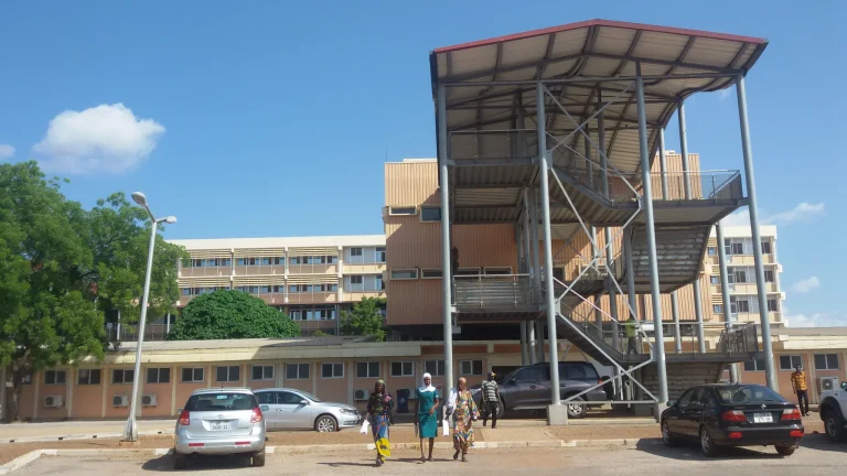
Tamale Teaching Hospital
Ghana-related teaching hospital discovered through the hosts relationship for Tamale, Ghana.
Continue Reading →